Click to show/hide Page 1 contents
• Goals and Objectives
• General Objectives for VFEs
• VFEs across the curriculum
• Using VFEs to foster rich discussion
Click to show/hide Page 2 contents
• Objectives specific to the Colorado River VFE
• Background
• The Colorado River Delta VFE
Click to show/hide Page 3 contents
Tools of real and virtual fieldwork for scientific inquiry
• Questions to guide field inquiry
• Productive field inquiry raises new questions
• A photograph is a dataset
• How to look at a specimen
• Consider the most important takeaways
Using Virtual Fieldwork as a catalyst for actual fieldwork
"Why does this place look the way it does?" is the driving question for our work and we've developed series of questions that support the driving question. One series focuses upon the rock at a site, and the stories that can be read in the rock. Another set of questions focuses on the underlying geoscience, and a third addresses environmental science and ecology. All of them are framed so that they can be productively investigated at any site.
Click here for a worksheet that includes the questions focused on the rock. The geoscience and environmental science question lists are more detailed series of questions are available as part of a packet with a series of checklists for preparing for field work. Content from that packet was expanded into a chapter, "Real and Virtual Fieldwork," from the Teacher-Friendly Guide to the Geoscience of the United States.
These checklist questions can be customized to highlight the special features of a site. A worksheet with questions specific to the Colorado River Delta is here showing one example of what that might look like.
While these question sets include attention to human impacts, we hope to develop another set of questions (in partnership with social science educators) that draws focus on the role of human activities in shaping the environment. Most of the places we go have been profoundly shaped by human activity, and we invite you to give this serious consideration in your field work.
Virtual fieldwork offers the opportunity to explore an area without leaving the classroom, and it allows multiple “visits” to a site. “Why does this place look the way it does?” is a bottomless question, meaning that it can be productively investigated for a very, very long time. Field scientists, be they professionals or fifth graders, will never fully answer this driving question absolutely or at every scale. Many of the supporting questions also have a bottomless quality.
These big questions can be used to drive discussion and investigation, and they can be used in graded assignments. The teacher can define the level of detail students are expected to use in graded work. Many of these questions can serve as catalysts for research papers or projects, but they can also be meaningfully answered in a concise paragraph.
Most of our VFEs are built around sets of imagery, some of which is interactive. Consider what you see as a dataset - or at least as a set of data, as "dataset" often refers to specific kinds of computer files. A photograph can contain a tremendous amount of data and also help to place other data into context, especially if the photograph is of very high resolution.
Kettleman Hills - Macoma Zone. Note that this image is an interactive Gigapan panorama. Use your mouse and the controls in the upper right corner of the image to view fullscreen, and to pan and zoom. View this Gigapan on its own page here to see additional features and to learn more about the Kettleman Hills. Please Note: All fossil localities in the Kettleman Hills are no longer accessible to amateur fossil collectors.
Consider and discuss what kinds of data can be included in a photograph taken in the field, and discuss how photographs can help provide context for other kinds of data. What can be interpreted about the nature of a place by interpreting photographs of that place? What kinds of information are easy to capture with a photograph? What kinds of data are more challenging to capture this way? As you look at different VFEs, ask yourself, "What do I wish the authors had taken pictures of?" And, "How could the photographs better capture aspects of the site, to help us understand why the place looks the way it does?" Use these questions to help you think about what to do when you create a VFE of your own.
Instruments can extend and sharpen our senses. Your sense of sight, of course, is not the only sense used in interpreting a field site. See The Teacher-Friendly Guide to the Earth Science of the United States' chapter, "Real & Virtual Fieldwork" for more on using instruments to extend the senses.
Most of our VFEs provide the opportunity to take a close look at at least a few rocks, fossils or biological specimens. That may not sound all that interesting, but any of these can tell a story, if you know how to read it. What is a Fossil helps you to "read" a fossil, and How to Look at a Rock provides a good basic overview of how to begin to "read" that story for rocks. While the description is focused upon rocks, many of the ideas apply to a broad range of types of specimens.
The article begins by stressing the importance of context. Knowing where a rock, fossil, or biological specimen was originally found is tremendously helpful. A specimen's location data gives you information about its story. The loss of this data makes a specimen much, much less valuable from a research perspective, like a paragraph out of novel, without the surrounding story, without the surrounding context, the specimen in isolation makes little sense.
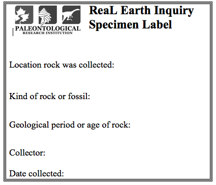
When you collect specimens in the field, therefore, labelling them is profoundly important. Bag your specimen and insert a label like the one below. Click the caption to download labels to print, or make your own.
A specimen label. Click here to download labels that print six to a page.
From field investigation, you can learn a lot about the story of a place - how a landscape came to be the way that it is. This is, of course, deepened by other kinds of research, both in the lab and in the library. We do think learning the story of a place is important, but for most learners, the details of how plate tectonics and climate shaped a particular environment are not the most important understandings, or the understandings that we hope will prove most durable.
By durable understandings, we mean big ideas that the learner will remember and understand for years after instruction. We have carefully crafted a set of Earth Science Bigger Ideas and Overarching Questions and we hope students and teachers will revisit them and consider their connections to their investigations. The Overarching Questions, "How do we know what we know?" and, "How does what we know inform our decision making?" are as important as the Bigger Ideas themselves.
Engaging in fieldwork (and the research in the lab and library to support that fieldwork) helps us to understand how scientific stories are unearthed. To understand how scientific stories are unearthed is at least as important as understanding those scientific stories themselves.
The VFEs we have created help tell the stories of the places they represent. While they can, to some degree, stand in the place of actual fieldwork, that is not their primary intention. When you visit a Virtual Fieldwork Environment, consider how the place you are studying compares with your local environment and other environments you have studied. How are the environments similar and how do they differ? Consider too how you can make a VFE of your local environment that you can share with others to teach them about where you live (or the field sites you visit).