Critical Zone Observatory Workshop

This workshop will both provide an introduction to Critical Zone science and 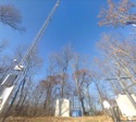 strategies for investigating the Critical Zone with your students through the creation and use of Virtual Fieldwork Experiences (VFEs). VFEs are multi-media representations of actual field sites. The driving question for the work is, “Why does this place look the way it does?” While VFEs may stand in for actual field experiences, they are more intended to catalyze fieldwork and serve as a way to document and share work in the field. Through teacher-student collaborations, learners engage in documenting the close study of their local environment in a way that facilitates sharing with interested others, and allows for years-long interdisciplinary investigation.
To learn more about the pedagogy of virtual and actual fieldwork see Real and Virtual Fieldwork: "Why Does This Place Look the Way it Does?" from the Teacher-Friendly Guide to the Earth Science of the US, and, About Making Virtual Fieldwork Experiences: Resources From the ReaL Earth Inquiry Project & the Critical Zone Observatory Network (also embedded immediately below). And, explore virtualfieldwork.org to learn more.
The workshop was held at Penn State’s Shaver’s Creek Environmental Center, which is adjacent to the Shale Hills - Susquehanna Critical Zone Observatory.
Workshop Goals:
The workshop is intended to:
-
•provide an introduction to Critical Zone science;
-
•provide an introduction to the use and production of Virtual Fieldwork Experiences (VFEs) in educational settings and;
-
•strengthen educator networks.
The workshop will also provide resources that support teaching in the field more broadly, most importantly, a set of questions that can be applied to the investigation of any field site.
Who should attend?
We expect the majority of the participants will be middle and high school science teachers, but the program is open to educators at any level. Educators from grade school ot grad school and from informal educational institutions including museums, and nature centers are welcome.
What to bring:
-
•Dress comfortably, casually, and appropriately for the weather. We will spend about an hour in the field, so shoes appropriate for walking on trails are important.
-
•A lap top computer is recommended
-
•Insect repellent
-
•Sun screen
-
•You may also wish to bring a tablet, smartphone, or digital camera but it is not required. Check back later for a list of suggested apps. Note that some are mentioned in the Prezi above.
-
•Optional apps for smartphones and tablets:
-
✦Whatever camera app is on your phone or tablet. Generally, photos taken on a smartphone or tablet (with data plan) include location data for where the picture was taken.
-
✦Skitch - allows for easy annotation of pictures while in the field. It also includes the ability to label and share maps. Skitch is now owned by Evernote and integrates with Evernote’s other products. (http://skitch.com/)
-
✦Photo Sphere - a 360 degree panorama app developed by Google. It allows you to create Street View-like images anywhere and embed them into Google Earth and Google Maps. An example is below. (http://www.google.com/maps/about/contribute/photosphere/)
-
✦Photosynth - another 360 degree panorama app from Microsoft. Photosynth also has a web-based app that accepts photos from any digital camera and has more options than the 360 degree panorama. (http://photosynth.net/)
-
✦Zoom - a video-conferencing app and desktop application that allows easy live video from the field to the classroom. The user interface is essentially the same across platforms. (http://zoom.us/).
-
✦Prezi - a web-based presentation software package. Be sure to register as an educator, as more features are available free to educators than to normal humans. There is an app as well as a desktop version. (http://prezi.com/)
Tentative Agenda:
-
1:00 - Introductions and goals of the workshop - Act 48 paperwork
-
1:15 - CZO overview
-
1:45 - VFE intro - the Shale Hills VFE
-
• Geoscience Questions Checklist (pdf)
-
• Cross-Category Checklist (pdf)
-
• See more in the Prezi above and here.
-
2:25 - into the field - CZ is everywhere!
-
3:30 - CZ in your classroom
-
3:40 - Working in the field
-
3:50 - Return to the VFE
-
4:45 - Wrap-up and evaluation - Act 48 paperwork
More about VFEs:
The video below gives a brief overview of our prior work on Virtual Fieldwork Experiences.
For a broader overview of PRI’s national outreach, see the video below.
Example Technologies:

This program is based upon work supported by the National Science Foundation.
Any opinions, findings, and conclusions or recommendations are those of the authors and do not necessarily reflect the views of the National Science Foundation.
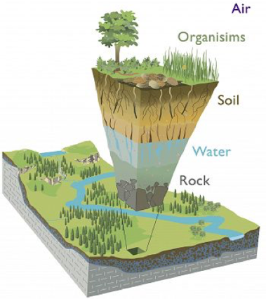
what is the Critical zone?
See: http://criticalzone.org/ for much more information.
From the bottom of the groundwater to the tops of the vegetation is where most life resides. Geologists, ecologists, climatologists and other scientists are doing 3D (NGSS) science in an NSF-funded network of observatories to better understand the Critical Zone.
Fundamental Questions:
Despite the Critical Zone's importance to terrestrial life and many environmental issues, it remains poorly understood. Key questions include:
-
• How does the Critical Zone form?
-
• How does it operate?
-
• How does it evolve?
There are many followup questions as well. For example:
-
•How will the Critical Zone respond to projected climate and land use changes?
See more questions about the Critical Zone at: http://criticalzone.org/national/research/.
About the Workshop:
This site will be updated as the workshop approaches. The registration form is at the bottom of the page and here.
Check back for updates. Last update: July 24, 2015.