ContactFundingFAQAbout

The technology of ReaL Earth System Inquiry

(ReaL stands for Regional and Local)

The project engages a wide variety of technologies. Most are either essentially ubiquitous (Internet connected computers and Microsoft Office) or very inexpensive.

This page is intended to serve as a reference; to illustrate some of the things possible. It is unlikely that any project participant will use more than a few of the many technologies described here. Any project participant who wants to explore any of these technologies further should let Don know.

Social Networking Software

Skype allows for free conference calling for up to five participants. Only the person initiating the call needs to be at a computer. Currently, there is no charge to call regular phones, though Skype intends to charge beginning in 2007. Computer to computer calls will remain free. The software is also free and available at http://skype.com. This has facilitated teacher study groups involving teachers from across the state. Ideally, teachers are seated at Internet connected computers as we often share documents or web sites during the calls.

Calls are recorded for analysis using WireTap Pro. The software allows you to record from both Mac Audio and the built in (or external) microphone. Audio can be saved in any commonly used format. It is made for Mac OSX. WireTap Pro is also used for recording interviews.

Flickr offers free hosting of digital photgraphs. Flickr's homepage is http://www.flickr.com. Examples of teacher photographs from Akron Falls and the Adirondacks can be found by clicking on the embedded links.

Software for photo editing and management

Apple's iPhoto was used for creating all the photo galleries hosted on this site. See Breakneck Point, for example. iPhoto comes installed on all modern Macintosh computers. To create these galleries, select 'Export' from the 'Share' menu. Save an album as a web page and save it to your web site.

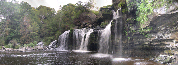
Panoramas were created using Adobe's Photoshop Elements (version 4.0 for the Mac OSX). To create images like the one at the top of this page, select 'New' from the 'File' menu and then select 'Photomerge Panorama.' Of course, you will first need a set of photographs to merge together. The panoramas included on this site at this writing (October of 2006) are far from perfect. The camera was almost always hand held and exposures were done automatically.

Gimp is freeware for photo manipulation.

iPhoto also allows you to take photo albums in your pocket (on an iPod). See below.

Flickr, described above, allows for storing, sharing and sorting digital photographs.

For the future?

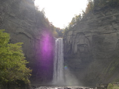
Quicktime VR Panoramas offer exciting potential. See some created by others not associated with the project:

http://www.learningtoflyoriginals.com/panorama.html Scroll down to find Taughannock Falls.

http://www.hudsonriver.com/panoramas/breaknec.htm. For other panoramas, remove the text after the last '/'. (This is often an effective strategy for finding more material like whatever page you are visiting).

Google Earth

Google Earth was used for connecting the virtual field trips from across the state. The software is free (though a more powerful pay versions are available). The map of New York State on the project homepage is a Google Earth image showing most of the VFTs.

The software is memory intensive, but very simple to use. An Earth science teacher can begin using the software in classes after a very short period of exploration.

Creating within the software is a step more complex, but not overwhelmingly so. I skipped over the tutorial and went to the DLESE NY Landscape Regions in Google Earth page. Amazing stuff created by these folks.

I was quickly able to create my own materials by downloading some of these tours and choosing to edit them. I then could easily see (and copy) the basic commands to do what Steve and colleagues had done.

To do this, select a tagged location and from the 'Edit' menu select 'Properties.' (I've just downloaded version 4.0 of Google Earth, and they've changed the menus slightly. It's now 'Get Info' instead of 'Propeerties.') The images in windows are called up from the web, so you need to have the images you wish to display within Google Earth posted on the web. To copy the URL of an image, right click on the image in your browser.

Download the ReaL Field Trips kmz file here.

iPod

An iPod can do more than play music. While at Taughannock Falls planning a field trip with a group of teachers, we were able to stand at the end of the trail looking up at the falls and switch between before and after pictures of a rock fall.

Of course, this can be done by bringing photos with you, but the iPod can allow you to carry tens of thousands of photographs in your pocket.

DSCN0181.JPG

Rollover the image on the right to switch between before and after the rockfall. Watch the tongue of rock. Taughannock Falls is 215 feet high -- 55 feet higher than Niagara Falls. With that bit of information, you can get a fair idea of the size of that massive rock. Additional photographs of Taughannock (both before and after the fall) are found on the ReaL homepage.

Web Page Authoring Software

Any widely used newer software package for web design will allw users to create things like the embedded pictures here, or the rollover image directly above. This site was created with Adobe GoLive for the Macintosh (Version 7.0.2). Sarah Miller's website was created using Microsoft FrontPage. Virtualfieldwork.org was created using Apple's iWeb.

Inspiration Software

Sarah Miller's graphic organizer for virtual field trips was created using Inspiration software. Don created Big Idea maps using Inspiration.

PowerPoint Software

MicroSoft's PowerPoint is used extensively in both conference presentations and in teacher's classrooms. There is a Mac version of PowerPoint too. Note that the embedded maps used in web sites, as well as internal links can be included in PowerPoint presentations. Presentations can also be saved as web pages, like this one.

Open Office is freeware that includes presentation software as well word processing and spreadsheets.

Future Considerations

Skypecasting extends the group size possible in a conference, but all participants need to be using a computer. Couple this with Google Docs & Spreadsheets, where individuals in different locations can work simultaneously on the same document and a new range of possibilities opens for teacher collaboration.

Moodle extends the possibilities even further.

These three products are all currently available at no cost.

Site Meter