Real earth system science

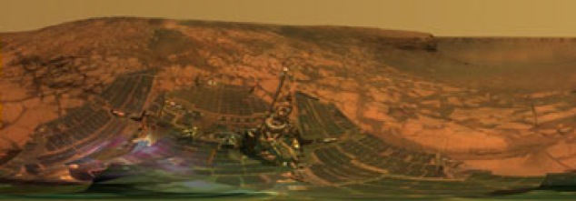
The Mars Rover missions illustrate well what we are setting out to do. Like teachers in under-resourced school, NASA can’t afford to send scientists to Mars, at least not in a flesh-and-blood sense. The costs are too high and the physical risks too great. It would take a long time too. These are the same kinds of challenges teachers face in planning field trips (though the scales differ by several orders of magnitude).
Somehow though, real scientists are doing real science without actually visiting the place they are studying. As in a “real” field trip, these scientists can choose to take a closer look at things of their choosing – within certain limitations, of course. In line with the goals we have for our pedagogical approach, these scientists are using their understandings of local processes to understand processes taking place somewhere they themselves cannot physically visit. The layering in the rock of the rim of Mars’ Victoria crater looks strikingly like the fossilized dunes of Zion National Park, for example.
In a way, we as the creators of VFEs are playing the role of the robotic rovers. We use some of the same techniques – panoramic photos for one. We may also be able to return to the site to gather more data as a result of our students’ questions just as scientists can guide the rovers to gather more data.
Another important idea is to connect multiple missions that work across multiple scales. If the rovers were the first Mars missions, there would be no maps used to plan their journeys. As they work, the Reconnaissance Orbiter gathers more data that informs the rover missions. Like the Mars missions, we use satellite and aerial imaging to help us see the lay of the land and we look closely at individual rocks (and we look at levels between those extremes).
The mother of all virtual fieldwork experiences