Things to bring into the field:
- Backpack (preferably old, the main purpose is to have something to carry
rock samples)
- In backpack:
- First-aid kit
- Water
- Ziploc bags (perfect for shales and anything else that is crumbly)
- Grocery bags (collecting other rocks)
- Pencils (mechanical are best because they don't need to be sharpened
and won't run in the rain)
- Sharpies (to label rock samples)
- Digital camera (make sure batteries are charged and/or you have extras)
- GPS unit (make sure batteries are charged and/or you have extras)
- Meter stick or other measuring device (for scale), mechanical pencils
can also be used on small objects
- A field notebook or clipboard and paper
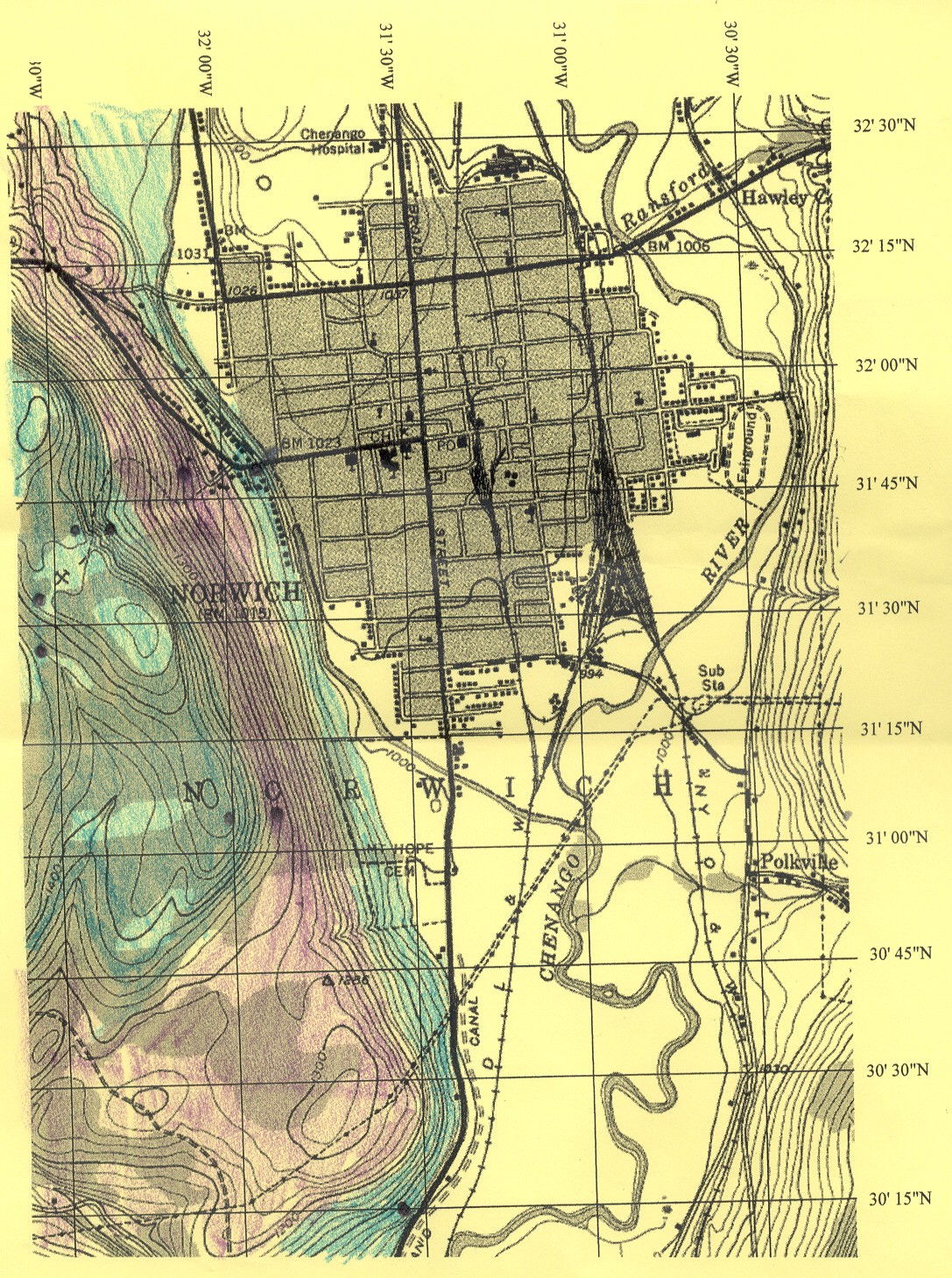
- A topographic map of the area, if possible
- Rock hammer and safety glasses (fresh surface of a rock can be quite
different from the weathered surface, or you may need to break rock to get a
hand sample for your classes, before using a rock hammer, be sure that its
okay to do so)
Things to do at each site:
- Get coordinates from your GPS (Write down the coordinates on paper even
if your GPS stores them, and don't trust the elevation it gives you)
- Take pictures:
-
Put something for scale in each picture
-
An overview
-
Examples of weathering and erosion
-
Any changes in rock type or color
-
Bedding
-
Close-ups of typical rock
-
Anything cool, interesting or something you
have questions about
-
Take as many pictures as you can, it may save you a
trip back!
- Take notes:
- Get samples:
- Typical rocks (enough samples to show what the place looks like in
terms of rock)
- Any rock with something special like fossils
- Atypical rocks (what's this doing here?)
- Anything you have questions about
- Label rocks/bags (I use the following system:)
- L1-06-01
- L1 stands for Location 1 (you can give places descriptive names
or numbers, what ever works for you)
- 06 stands for 2006
- 01 stands for the first sample at this location
Scaffolding A Virtual Fieldtrip
What skills do students need to be successful on a vft?
- Make observations
-
Mapping bedrock
-
Writing useful field notebook entries/ sketches
- Able to classify rock types/ identify specific rocks
- Be able to make connections between a rock and what it means
(formation)
- In Norwich depositional environments are very important
- Able to determine agents of erosion/ deposition from evidence
- Creating a geologic map
-
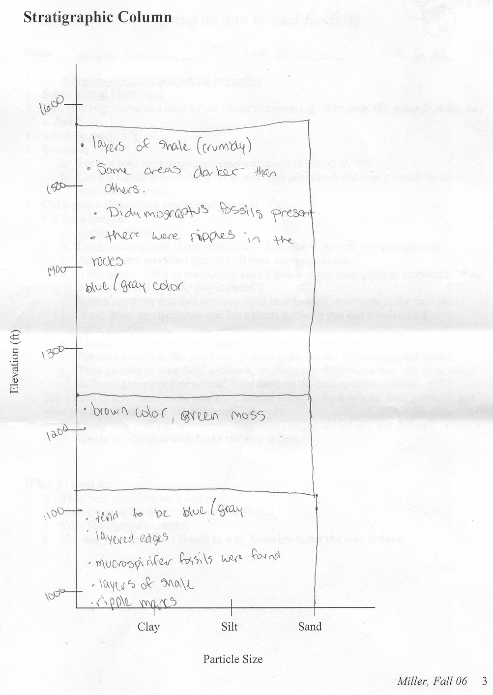
Drawing a stratigraphic column
-
Telling a story about a place
Are any of the below things helpful?
Introduction to Fieldwork: the Chenango River
Geologic Bedrock Maps
Student Guide/Work for Fall 06
Student guide with stratigraphic column in MSWord
Download
Topographic Map of Norwich in MSWord
Download
Geologic Map of West Hill in Norwich, NY created by student
Stratigraphic column of Norwich, NY created by the same student