This webpage serves as an introduction to both Critical Zone science and the use of Virtual Fieldwork Experiences (VFEs) for exploration of the Critical Zone. Embedded within this page you will find VFEs of the Shale Hills Susquehanna Critical Zone Observatory (CZO) and the Southern Sierra CZO. The page also addresses The Next Generation Science Standards. The page is written for both teachers and students.
Interpret the environment represented within the VFE you are investigating, including descriptions of why the landscape looks the way it does, and how it has changed over time.
Create a VFE representing your local environment or a field site you have visited and present it to interested others. Objectives for specific VFEs are included within those VFEs.
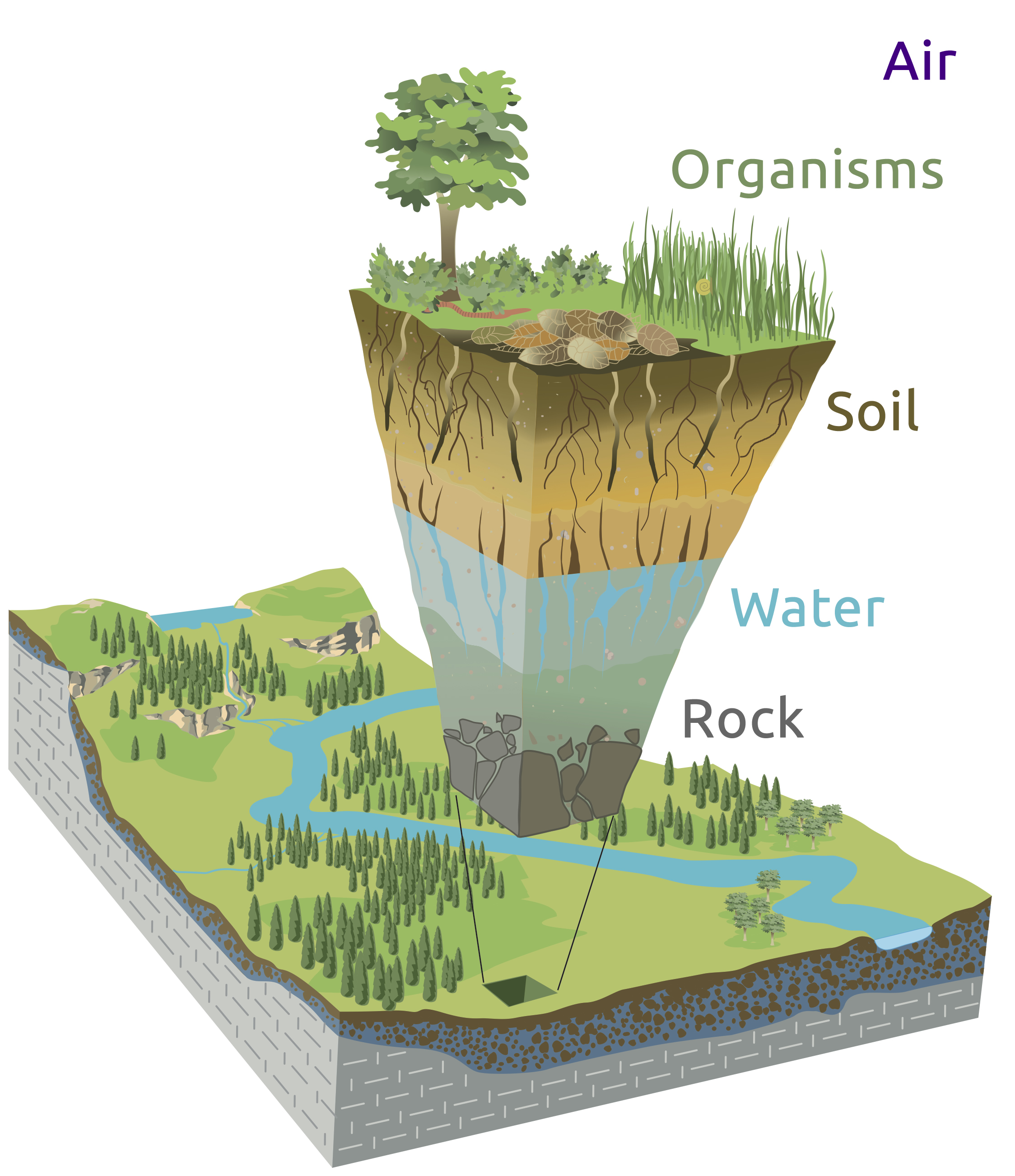
The Critical Zone (CZ) extends from the tops of the vegetation to the bottom of the water table. It is a thin veneer that makes life possible on Earth. In the Critical Zone, different cycles, including the carbon cycle, the water cycle, and the energy cycle all interact in complex ways we are just beginning to understand.
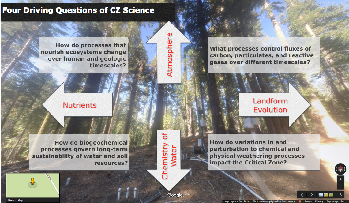
Nine National Science Foundation-funded observatories around the country are set in a range of environments and upon a range of lithologies. Interdisciplinary teams of scientists are studying the Critical Zone not only across a range of different geographies and different geographic scales, but also attending different temporal scales, from seconds to eons.
Illustration modified from Chorover, J., R. Kretzschmar, F. Garcia-Pichel, and D. L. Sparks. 2007. Soil biogeochemical processes in the critical zone. Elements 3, 321-326. (artwork by R. Kindlimann).
Despite the Critical Zone’s importance to life on Earth, its nature is poorly understood. Fundamental questions include:
- How does the Critical Zone form?
- How does it function?
- How will it change in the future?
The Critical Zone covers the entirety of the land on Earth, making it relevant to everyone, everywhere. Society and terrestrial life itself depends upon the services provided by the Critical Zone. These Critical Zone Services are not always explicitly considered in the management and use of natural resources. They should be.
Understanding Critical Zone science is important to everyone, and the Critical Zone is underfoot nearly everywhere. Getting to know your local environment and the nature of the Critical Zone within it is an excellent place to start. By studying how the Critical Zone is studied elsewhere - especially including at Critical Zone Observatories, you can learn how to more effectively learn about your local Critical Zone, and understand it in comparison to somewhere else. That comparison both deepens your understandings of the local environment and of the global environment. Further, it provides insights into environmental change and to humanity's roles in that environmental change.
A group of undergraduate and teacher researchers at the Shale Hills Critical Zone Observatory. Note that this image is an interactive Street View panorama.
This page is written in a way that is intended to serve an array of users. The most obvious audiences are teachers and students, but we hope that it serves anyone who wants to unearth the story of a place. Readers may engage in that exploration alone or together. There is a fair amount of text to explain different aspects of teaching and learning with Virtual Fieldwork Experiences and about Critical Zone science. While we think this is helpful, especially for those new to the approaches used here, experienced users of VFEs may skim through this text and move onto exploring the site with both the Prezi and the Google Earth file linked below.
In many field trip settings, whether virtual field trips like these, or at actual field sites, teachers or field trip leaders point things out. That can be interesting, educational, and fun, but the learning is likely to be more durable if the learner figures things out. Ideally, in working together, teachers will act as collaborators with students, and will work to figure things out together.
We also hope that sharing strategies for teaching and learning with the learners, as we are doing here, will help learners to be more metacognitive. Metacognitive learners are learners who actively learn how they learn, and work to manage and improve their learning processes.
A fundamental goal of learning in the geosciences is to be able to answer the question, “Why does this place look the way it does?” where “this place” is wherever you happened to be, or whatever location you happen to be studying. The question leads to a sort of “who done it?” – a mystery, or set of interlocking mysteries, to be solved. Unearthing these mysteries is rarely a simple task. A landscape is always the result of the interplay of many different processes, often over very long periods of time. There is never, or almost never, one single process that explains why a particular landscape is the way that it is.
Nearly every unit in an Earth or environmental science course, and most of the units in a biology course, play out in some meaningful way in most environments, including the one outside your classroom door. The table below lists units in typical Earth science and biology curricula. Look through the list and consider how each unit influences the landscape where you live and the landscape or landscapes you will explore through virtual fieldwork.
| Units in a typical Earth science course: | Units in a typical biology course: |
|---|---|
| • Introduction: Size, Shape, and Composition of Earth | • Introduction: Unity and Diversity among living things |
| • Mapping | • Maintenance in living things |
| • Rocks and Minerals | • Human Physiology |
| • Weathering, Erosion, Deposition, and Landforms | • Reproduction and Development |
| • Earthquakes and Plate Tectonics | • Transmission of traits from generation to generation |
| • Earth History & Paleontology | • Evolution (Note: Evolution is both a crosscutting theme and a unit.) |
| • Meteorology and Climate | • Ecology |
| • Astronomy |
It’s all there – each and every one of these curriculum units is happening outside your classroom door, outside the door of your home, and wherever your field site happens to be. Fieldwork, whether real or virtual, can be used to deepen understandings for any and all of these topics.1
While it is all there, there is also ambiguity. Doing fieldwork, whether virtual or actual, has substantial important differences from doing traditional schoolwork. We think that's a good thing. Reading the lay of the land, answering the question of why a place looks the way it does is complex work that both develops and requires the understandings of content from multiple disciplines and - at least as importantly - understanding the meaning of the connections amongst those disciplinary ideas. In other words, doing fieldwork is more like doing life than it is like doing schoolwork.
Much of what we do in school simplifies the seemingly complex. That is important to do much of the time, but it is also important to complexify the seemingly simple - to dig into the complex nature of how our world works. Fieldwork, whether real or virtual, provides excellent opportunities for studying the interplay of different Earth systems and processes. As you explore your field site, consider the connections amongst the processes of life, rock formation, and the nature of weather and climate. Then consider connections to other areas of science, and to disciplines beyond science.
There are a large range of possible learning objectives that can be satisfied exploring the content of this site. The most basic knowledge level objective are: Define the Critical Zone and describe its component parts. And: Describe common Critical Zone Services and why they are important to life on land.
Ultimately, we hope learners satisfy more sophisticated objectives that are higher on Bloom's Taxonomy. While we will share some objectives that might be addressed or satisfied in working with content of this site, we also recognize (and welcome the idea) that educators and learners will choose or develop their own objectives for their use of the site. In choosing to do that, they will be more metacognitive than those who simply follow whatever suggestions we happen to make.
High level objectives that we hope users aspire to include:
Interpret the environment represented within the VFE you are investigating, including descriptions of why the landscape looks the way it does, and how it has changed over time.
Create a VFE representing your local environment or a field site you have visited and present it to interested others.
These objective do lack specificity in terms of the level of detail for explanations and the scale of the VFE to be created. Educators might determine this before working with their students, or educators and students might work together to negotiate the scale of the explanations and models. Applying analogical reasoning to the interpretation of environments is an important skill used in field science and maybe a component of an objective.
The "interested others" mentioned in the second objective could be community members, or other classes. Inexpensive video conferencing allows the interested others to be a great distance away. We suggest connecting classrooms across the country, and can help facilitate that.
The sections on The Next Generation Science Standards below also addresses objectives.
The Next Generation Science Standards (NGSS) is a multi-state effort to create new education standards that are "rich in content and practice, arranged in a coherent manner across disciplines and grades to provide all students an internationally benchmarked science education." The NGSS presents science as "three-dimensional," where the three dimensions are "Scientific and Engineering Practices," "Crosscutting Concepts," and, "Disciplinary Core Ideas." These are shown in the table below.
This webpage assumes basic familiarity with NGSS. "The Teacher-Friendly Guides, Virtual Fieldwork, and the NGSS's Three-Dimensional Science," the appendix of The Teacher-Friendly Guide to the Earth Science of the United States, gives a general overview of how fieldwork, whether real or virtual, can be used in NGSS-informed instruction. It also can serve as an introduction to the NGSS.
For teacher-written descriptions of the kinds of conceptual shifts that the NGSS requires, see the Shifts page of the Practices Resources in Science and Math (PRISM) website. The site also includes video cases of NGSS-based teaching.
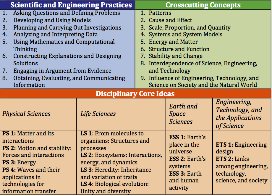 Summary of NGSS’s Three Dimensions. For more detailed descriptions, see the relevant appendices in The Next Generation Science Standards at http://nextgenscience.org/.
Virtual and actual fieldwork, and Critical Zone science are all very well suited to teaching three-dimensional science in ways that resonates with NGSS. Here's an extended excerpt from the appendix mentioned above.
Deep understandings of why your local environment looks the way it does requires understanding the local environment from multiple disciplinary perspectives, and understanding the connections amongst these different disciplinary ideas. That is, to understand your local environment, a systems perspective is needed. Scientifically accurate meaningful understanding can and does come out of single lessons, single units, and single courses, but these understandings become richer, deeper, and more durable if they are connected across courses. The NGSS vision includes recognition that building a deep understanding of big ideas is both very important and a process that takes years of coordinated effort. Fortunately, the many processes that shape the local environment are part and parcel of existing curricula, and especially for Earth science, biology, and environmental science courses, nearly every unit has central aspects that play out on a human scale just outside the school door. A coordinated approach to the study of the local environment across units within a single course and across grade levels and courses can be a fairly subtle change in each teacher’s daily routines, but it has the potential for big returns in terms of the depth of student understanding. This deeper understanding pertains not only to the local environment and the way course topics are represented within it, but also to systems more generally, to the nature and importance of scale, and to much, much more.
The above excerpt, and the document it draws from are focused broadly. They do not focus on particular Performance Expectations, Disciplinary Core Ideas, Crosscutting Concepts or Science and Engineering Practices but on the big picture vision of the NGSS, and on a systems- and research-based approach to effective science teaching. Considering how a particular teaching approach satisfies specific standards is important, but it is fairly easy to lose sight of larger goals and begin to treat those individual aspects of the Standards as a checklist. The larger goals include transforming K-12 science education so that high school graduates are prepared for the duties of citizenship, further education, and the workforce.
Under the heading, "All Scientific and Engineering Practices and all Crosscutting Concepts in all courses," Appendix K of NGSS notes, “The goal is not to teach the PEs, but rather to prepare students to be able to perform them by the end of the grade band course sequence.” To help keep focus on these larger goals, we suggest hanging posters of the NGSS's Crosscutting Concepts, Science and Engineering Practices and Disciplinary Core Ideas on your classroom walls and referring to them regularly. The University of Illinois' Project Neuron makes pdfs of such posters available here.
One simple way to do that is to make questions about them a part of standard lab reports. This five-question lab summary offers an example of how to do that with a few straightforward questions. It includes a simple rubric, and is in Microsoft Word format so that it can be easily edited to suit teacher needs.
Of course, the Performance Expectations were developed for a reason. They, along with Evidence Statements (and other resources), give guidance on what NGSS-aligned instruction looks like. Excerpts of Evidence Statement, MS-ESS2-2 are below.
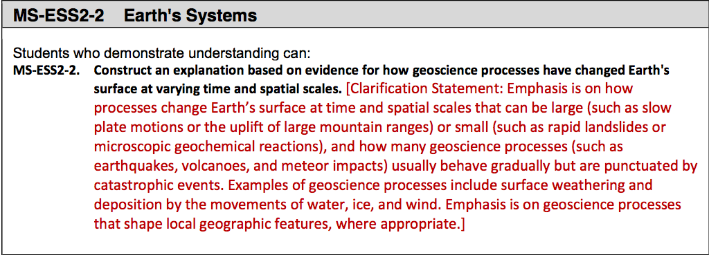
 Excerpts of Evidence Statement: MS-ESS2-2. See the full Evidence Statement here and see the related Performance Expectations here (both documents are pdfs).
The kind of science described in the example Performance Expectation and Evidence Statement can be well addressed by engaging in actual fieldwork exploring and describing the Critical Zone either outside your classroom door or through virtual fieldwork. And, this holds true for many, if not most, of the Performance Expectations within the NGSS. If looking at the level of Performance Expectation seems daunting, relax. Go back and look at the big picture ideas expressed within the Crosscutting Concepts and Science and Engineering Practices and consider how these are applied to the study of the environment. All of the guidance provided here is intended to support teaching that satisfies the NGSS, even if, or maybe especially if it is not focused on specific Performance Expectations.
We found the Ambitious Science Teaching Project's Discourse Primer for Science Teachers four high-level goals for talk resonate with our goals for the kind of conversations that VFEs should foster. These goals are shown below.
- Eliciting students’ initial scientific hypotheses in order to plan for further instruction. The goal of this discourse is to draw out students’ understandings of a phenomenon (e.g. a bicycle rusting in the backyard) that is related to an important scientific idea (in this case chemical change or conservation of mass). After the lesson we analyze students’ ways of talking about it in order to adapt upcoming learning experiences.
- Making sense of data/information. The goal here is to help students recognize patterns in data, critique the quality of data, and to propose why these patterns exist. What, for example, is going on at the unobservable level that explains our observations?
- Connecting activities with big scientific ideas. The goal of this practice is to combine data-collection activities with readings and conversation in order to advance students’ understanding of a broader natural phenomenon. This conversation is different from the previous one, in that students are not trying to explain the outcome of an activity, but to relate the activity to a bigger science idea or puzzle that the unit is framed around.
- Pressing students for evidence-based explanations. This discourse is designed to happen near the end of a unit, but elements of this conversation can also happen any time the teacher is trying to get students to talk about evidence. The goal of this discourse is to assist students in using multiple forms of evidence, gathered during a unit, to construct comprehensive explanations for a phenomenon that has been the focus of the unit.
From: A Discourse Primer for Science Teachers (p. 7). Available here.
Consider these goals as you explore and investigate your field sites - both the virtual ones represented here, and any site local to your home or school. While they are labeled here as goals for talk, they reflect goals for the kind of thinking teachers, students, and other learners should engage in as they deepen their understandings of scientific ideas.
As you explore our VFEs, you may wish for more explanations of some of the underlying CZ science. There are a number of reasons for that, but paramount among them is, "Explanation kills wonder," as Paul Anderson notes in his discussions of the NGSS. Unsurprisingly, that's difficult and perhaps inappropriate to explain, but it does support the fostering of rich discussion. This does not mean that explanation is never appropriate, but as teachers, we often explain too much, or give explanation before learners are ready to take them in. If we let learners wonder longer than we typically do, when they seek out explanations, the understandings are likely to be more durable.
You are. Science, like life and the world more broadly, is rarely something that points to one simple clear explanation, at least for things that really matter in the world. Science is messy business. Too often, school curriculum leads learners to a clear and straightforward answer. That isn't unreasonable for simple matters, but for things that are really interesting, for things that really matter, it's a problem.
Science is often confusing, and if students aren't confused at least some of the time, they probably aren't learning the science in a deep and meaningful way. The explorations presented here probably tell too much for students to walk away with deep understandings, but building understandings of the specific sites shown here is not the only purpose of the content on these webpages.
As you explore these virtual field sites, consider how the nature of these sites compares to your local environment. As you work through these resources designed to help you understand the environment in these places, consider how you can make a Virtual Fieldwork Experience of a place near where you live that others could use to learn about your environment. Then make a VFE to share what you have learned - or, make one to both share what you have learned and to process what you have learned. Why does your place look the way it does?
Given that most or all of the units within a course play out in nearly every terrestrial environment, fieldwork, whether real or virtual, can be a part of instruction in any unit. We suggest that you give attention to fieldwork in multiple units throughout your course, and draw comparisons between your local environment and the environments you visit virtually. Use fieldwork at the beginning of a course to establish the purpose of your investigations; interweave fieldwork throughout the course to highlight topics within each unit; and use fieldwork as a capstone to tie the course content together. Fieldwork may be used for any or all of these purposes, and it may make sense to choose one initial focus, especially if you have not led students in fieldwork previously. Remember that field scientists may visit the sites they research hundreds of times over their careers and continue to deepen their understandings with each visit.
Most VFEs that we’ve developed are customizable to teacher and student needs. Google Earth or Prezi files can be edited to allow focus on a particular feature in the landscape, or students may be directed to focus on specific topic. Generally, they also allow topics and questions to be investigated at different depths.
"Why does this place look the way it does?" is the driving question for our work and we've developed series of questions that support the driving question. One series focuses upon the rock at a site, and the stories that can be read in the rock. Another set of questions focuses on the underlying geoscience, and a third addresses environmental science and ecology. All of them are framed so that they can be productively investigated at any site.
Click here for a worksheet that includes the questions focused on the rock. The geoscience and environmental science question lists are more detailed series of questions are available as part of a packet with a series of checklists for preparing for field work. Content from that packet was expanded into a chapter, "Real and Virtual Fieldwork," from the Teacher-Friendly Guide to the Geoscience of the United States. These checklist questions are also embedded within the Prezi above, with slight customization for the special features of the site.
While these question sets include attention to human impacts, we hope to develop another set of questions (in partnership with social science educators) that draws focus on the role of human activities in shaping the environment. Most of the places we go have been profoundly shaped by human activity, and we invite you to give this serious consideration in your field work.
Virtual fieldwork offers the opportunity to explore an area without leaving the classroom, and it allows multiple “visits” to a site. “Why does this place look the way it does?” is a bottomless question, meaning that it can be productively investigated for a very, very long time. Field scientists, be they professionals or fifth graders, will never fully answer this driving question absolutely or at every scale. Many of the supporting questions also have a bottomless quality.
These big questions can be used to drive discussion and investigation, and they can be used in graded assignments. The teacher can define the level of detail students are expected to use in graded work. Many of these questions can serve as catalysts for research papers or projects, but they can also be meaningfully answered in a concise paragraph.
Most of our VFEs are built around sets of imagery, some of which is interactive. Consider what you see as a dataset - or at least as a set of data, as "dataset" often refers to specific kinds of computer files. A photograph can contain a tremendous amount of data and also help to place other data into context, especially if the photograph is of very high resolution.
A "CZ Tree" at the Southeran Sierra Critical Zone Observatory. CZ Trees have monitoring instrumentation embedded within the tree and into the root mass. Note that this image is an interactive Street View panorama. Use your mouse and the controls in the upper right corner of the image to view fullscreen, and to pan and zoom.
Consider and discuss what kinds of data can be included in a photograph taken in the field, and discuss how photographs can help provide context for other kinds of data. What can be interpreted about the nature of a place by interpreting photographs of that place? What kinds of information are easy to capture with a photograph? What kinds of data are more challenging to capture this way? As you look at different VFEs, ask yourself, "What do I wish the authors had taken pictures of?" And, "How could the photographs better capture aspects of the site, to help us understand why the place looks the way it does?" Use these questions to help you think about what to do when you create a VFE of your own.
Instruments can extend and sharpen our senses. Your sense of sight, of course, is not the only sense used in interpreting a field site. See The Teacher-Friendly Guide to the Earth Science of the United States' chapter, "Real & Virtual Fieldwork" for more on using instruments to extend the senses.
Most of our VFEs provide the opportunity to take a close look at at least a few rocks, fossils or biological specimens. That may not sound all that interesting, but any of these can tell a story, if you know how to read it. How to Look at a Rock provides a good basic overview of how to begin to read that story. While the article is focused upon rocks, similar strategies apply to making sense of other kinds of specimens. What is a fossil? explores the techniques paleontologists use to identify fossils.
How to Look at a Rock begins by stressing the importance of context. Knowing where a rock, fossil, or biological specimen was originally found is tremendously helpful. A specimen's location data gives you information about its story. The loss of this data makes a specimen much, much less valuable from a research perspective, like a paragraph out of novel, without the surrounding story, without the surrounding context, the specimen in isolation makes little sense.
When you collect specimens in the field, therefore, labelling them is profoundly important. Bag your specimen and insert a label like the one below. Click the caption to download labels to print, or make your own.
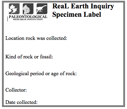
A specimen label. Click here to download labels that print six to a page.
Looking, more broadly is an important skill, and one that can be learned. Drawing sketches of what you see helps push learners to look more carefully. Reading the essay, In the Laboratory with Agassiz (also known as, "Look at Your Fish!") by Samuel Scudder is helpful for thinking about how drawing can help you see.
From field investigation, you can learn a lot about the story of a place - how a landscape came to be the way that it is. This is, of course, deepened by other kinds of research, both in the lab and in the library. We do think learning the story of a place is important, but for most learners, the details of how plate tectonics and climate shaped a particular environment are not the most important understandings, or the understandings that we hope will prove most durable.
By durable understandings, we mean big ideas that the learner will remember and understand for years after instruction. We have carefully crafted a set of Earth Science Bigger Ideas and Overarching Questions and we hope students and teachers will revisit them and consider their connections to their investigations. The Overarching Questions, "How do we know what we know?" and, "How does what we know inform our decision making?" are as important as the Bigger Ideas themselves.
Engaging in fieldwork (and the research in the lab and library to support that fieldwork) helps us to understand how scientific stories are unearthed. To understand how scientific stories are unearthed is at least as important as understanding those scientific stories themselves.
Whether the fieldwork is actual or virtual, it can (and we think should) be used to highlight two key ideas:
Further, virtual fieldwork is a user-friendly way of documenting, analyzing and sharing lessons learned from doing actual fieldwork.
These overarching ideas are likely more important than specific lessons about a particular site. Connected ideas include that understanding the connections between and among different Earth processes are as important as understanding the processes themselves, that scientists work develop durable understandings of the answers to these questions, and that students can engage in these questions as professionals and in service to meeting their obligations as informed citizens.
The VFEs we have created help tell the stories of the places they represent. While they can, to some degree, stand in the place of actual fieldwork, that is not their primary intention. When you visit a Virtual Fieldwork Environment, consider how the place you are studying compares with your local environment and other environments you have studied. How are the environments similar and how do they differ? Consider too how you can make a VFE of your local environment that you can share with others to teach them about where" you live (or the field sites you visit). Ideally, engaging in Virtual Fieldwork leads to doing actual fieldwork.
1 Human physiology is a bit different than the rest of the units as it focuses on a single species.