Real Earth System Science

A Google Map should appear here. If it doesn’t, scroll down to see what to do.
Over the course of the project (and beyond) we have created an online database of VFEs. Click on the placemarks in the map below to explore our collection of VFEs. Clicking on a site to see:
-
 The title of the VFE
 -
The author(s) of the VFE
-
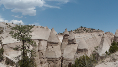
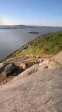
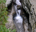
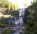
An iconic image or iconic images from the site. Iconic images should show image that comes to mind when you think of that site. A few VFEs involve multiple sites and these include more than one iconic image.
-
A VFE abstract that gives a brief overview of the target content, audience, and duration. Audience and duration are often stated as ranges as they are adaptable to different settings.
-
The software required to use the VFE.
-
One or to links two the VFE resources.
VFEs are intended to catalyze fieldwork and serve as models for how actual fieldwork experiences can be documented and shared. Learn more about the production and use of VFEs in The Teacher-Friendly Guide to the Earth Science of the Midwestern US.
A VFE Database
Check back soon at this page for more links to VFEs.
An illustrative vignette about VFEs is here.
Read about the Mother of All VFEs here.
VFE Resources More coming, including:
-
 Technological tools for VFE creation,
 -
Student VFE activities,
-
Evaluation & assessment tools
Changes are underway!
If there is no map, please send an email to let us know and we’ll fix it as quickly as we can!
The map was created using Google Fusion Tables.
We aspire to redesign and expand the VFE database in a new format and that will hopefully be online soon. See more about the new database here:
http://realearthsystemscience.blogspot.com/2011/05/and-suddenly-inquiry-evaporated.html
This includes links to the working draft, but it’s helpful to read the description before viewing the database. Google Fusion Tables may facilitate the delayed work.
You can access the current draft of the data entry form here.
The VFE Database Mapper