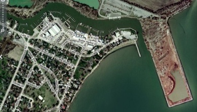
Bolles Harbor & Sterling State Park,
Monroe, MI

Bolles Harbor & Sterling State Park,
Monroe, MI
This page is prepared in advance of our workshop, with all images compiled from the web. Clicking on any image will take you to the source page.
This page is intended to provide links to relevant resources about the field site, primarily for the workshop participants and organizers.
Geology Resources:
The National Geologic Map Database
As the name indicates, this USGS site includes geologic maps from all over the United States. Relevant maps and reports for around Monroe, MI include Summary of Hydrogeologic Conditions by County for the State of Michigan and . The Edwards aquifer is an important aquifer, and geology is very important to the Texas economy, so there are many more relevant publications, though many are more technical than is needed for our work.
Digital Geologic Maps of US States
This site allows you to either view interactive maps in your browser window or download them as kml or kmz files for use in virtual globes like NASA’s Worldwind and Google Earth. Click on a rock unit and you will be taken to a web page with a detailed description of the unit.
Bolles Harbor lies at the corner of three USGS quadrangle topographic maps: Stony Point, Monroe, and, Erie. Comparing these maps, which date from 1979 - 1992 with what the Harbor currently looks like shows substantial change. The USGS is currently updating their topographic maps and new quadrangle maps of the area should be available soon.
GPS Visualizer is a website that allows you to create Google Earth overlays of USGS topographic maps as well as create other Google Earth materials. The software embedded in the site combines the quadrangle maps if the area mapped includes more than one quadrangle.
See also the VFE Resources page!
Suggested additions are welcome.
Please email Don Duggan-Haas at [email protected].
Draft VFE Components:
The following links allow you to download the resources created thus far for the Bolles Harbor & Sterling State Park Virtual Fieldwork Experience. They are still under development and review. Please send comments to Don Duggan-Haas.
Google Earth Tour of Bolles Harbor & Sterling Lake State Park. This includes several embedded photographs, many with questions, as well as overlays of soil, and topographic maps. And more.
Question Specific Materials
Describe the Shape of the Land.
• Nicole’s Shape of the Land Questions (.doc)
• Bill’s Monroe Michigan, Why so flat? (ppt)
What Effects Has Water Had on the Landscape?
•
What Effect Has Climate Had on the Landscape?
•
Do the Rocks Form a Sequence?
•
What Types of Rocks Are There?
•
What Effects Has Life, Including Human Life, Had on the Landscape?
•
Resources for Developing a VFE

A brief introduction
The Charles & June Knabusch Mathematics & Science Center sits close to the shore of Bolles Harbor on Lake Erie in Monroe, MI. The facility provides opportunity for hands-on experiences in the natural world using Lake Erie and the surrounding environment as a learning laboratory for problem solving, observing, and discovery. The facility has deep-water access to Lake Erie, 2 large ponds, and a diverse set of terrestrial environments.
In July of 2010, staff from the Paleontological Research Institution and its Museum of the Earth in partnership with the staff at the Knabusch Center will begin a teacher professional development program at the site.
Last update: July 26, 2010.
Workshop Materials:
Check back for additions before, during and after the workshop. Also see the workshop preparation page.
Here are links to the tentative agenda (revised 7/14/10)
.pdf
.doc
Wednesday’s Slides (a subset):
•ReaLly Big Ideas (Don) (.ppt) (.key) (.key with audio (large file)) (.mv4 (large file, video viewable in iTunes or Quicktime))
•Bolles Harbor Geoscience Overview (yet to come)