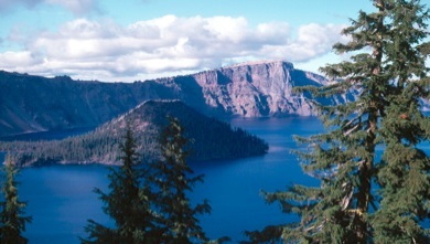
Crater Lake, OR

This page is prepared in advance of our workshop, with all images compiled from the web. Clicking on any image will take you to the source page.
This page is intended to provide links to relevant resources about the field site, primarily for the workshop participants and organizers.
General Resources:
This is the official park website and has a great deal of information. Pages include Current Conditions, Photo Galleries, and much more.
The Crater Lake Institute is an independent non-profit organization the advocates for the park and its protection. The Institute’s homepage features links to resources about the park’s natural history, art, what you need to know for planning a visit and a link for the Institute’s Facebook page.
The Crater Lake Digital Research Collection
Quoting from the Research Collection’s ‘About’ page:
-
This digital library is a collaborative project between the Oregon Institute of Technology Library and Crater Lake National Park. It is a research collection of park-related scientific and historical/cultural materials for use by researchers, educators and others.
Geology Resources:
Many of the links above also provide good information on the Park’s geology.
The USGS Cascades Volcano Observatory
Quoting from the site:
-
-
The U.S. Geological Survey's Cascades Volcano Observatory (CVO) strives to serve the national interest by helping people to live knowledgeably and safely with volcanoes and related natural hazards including earthquakes, landslides, and debris flows in the western United States and elsewhere in the world. CVO assesses hazards before they occur by identifying and studying past hazardous events. We provide warnings during volcanic crises by intensively monitoring restless volcanoes and interpreting results in the context of current hazards assessments. We investigate and report on hazardous events after they occur to improve our assessment and prediction skills, and to help develop new concepts of how volcanoes work. -- Excerpt from: Preparing for the Next Eruption in the Cascades, 1994
The site includes an information page on Crater Lake and Mount Mazama with links to many, many resources. Also included is a page of “Maps and Graphics, etc.” for Crater Lake.
The Geologic History of Crater Lake National Park
This page from the aforementioned Crater Lake Institute provides links to many authoritative sources on the geologic history of the Park. The resources vary in length and level and include both online and print resources.
Check out GSA's growing collection of online field guides. You can browse pages from the newer volumes using the Google Books link in the Book Reviews section. And be sure to check out Field Guide 3 — all six chapters are open access. Individual papers from all volumes can be purchased via Bloc of Docs subscription for as little as $4 each.
The National Geologic Map Database
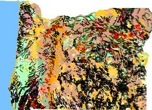
As the name indicates, this USGS site includes geologic maps from all over the United States. Relevant maps and reports for Crater Lake includes the Geologic map of Mount Mazama and Crater Lake Caldera, Oregon.
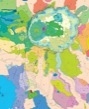
Digital Geologic Maps of US States
This site allows you to either view interactive maps in your browser window or download them as kml or kmz files for use in virtual globes like NASA’s Worldwind and Google Earth. Click on a rock unit and you will be taken to a web page with a detailed description of the unit.
Crater Lake is divided between two USGS quadrangle topographic maps: Crater Lake East, and Crater Lake West. Maps at other scales are also available. The USGS is currently updating their topographic maps and new quadrangle maps of the area should be available soon.
GPS Visualizer is a website that allows you to create Google Earth overlays of USGS topographic maps as well as create other Google Earth materials. The software embedded in the site combines the quadrangle maps if the area mapped includes more than one quadrangle.
See also the VFE Resources page!
Suggested additions are welcome.
Please email Don Duggan-Haas at [email protected].
Draft VFE Components:
The following links allow you to download the resources created thus far for the Bolles Harbor & Sterling State Park Virtual Fieldwork Experience. They are still under development and review. Please send comments to Don Duggan-Haas.
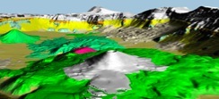
Google Earth Tour Crater Lake. This currently only includes two map overlays. One is a geologic map, the other is topographic.
Question Specific Materials
How do the valleys, mountains, or hills, relate the story of the landscape?
-
•
What effect has climate had on the landscape?
What story do the rocks tell?
What types of rocks are there?
-
•
What factors control species diversity and abundance at Crater Lake?
-
•
Why is the water so blue?
Resources for Developing a VFE
A brief introduction
Why does Crater Lake look the way it does?
Approximately 7,700 years ago Mount Mazama, the hypothetical mountain whose remnants now hold Crater Lake, erupted spectacularly in a caldera eruption. In the centuries following the eruption, the crater filled creating the deepest lake in the United States and its depth and purity renders it a stunning deep blue color.
In July of 2010, staff from the Paleontological Research Institution and its Museum of the Earth in partnership with the education staff at Crater Lake National Park began a teacher professional development program at the park. Together with a group of select educators, we’ll work to understand why this place looks the way it does and to create resources to help others understand as well.
Last update: July 14, 2010.
Workshop Materials:
Check back for additions before, during and after the workshop. Also see the workshop preparation page.
Here are links to the tentative agenda (revised 7/14/10)
.pdf
.doc
Wednesday’s Slides:
-
•Crater Lake Geology Overview (Sara) (ppt)
-
•ReaLly Big Ideas (Don) (.ppt) (.key) (.key with audio (large file)) (.mv4 (large file, video viewable in iTunes or Quicktime))
Wednesday Night’s Reading:
Geologic Overview of Mount Mazama and the Crater Lake Caldera by William Hirt, College of the Siskiyous