Craters of the Moon VFE Student Page

VFE Abstract
Craters of the Moon National Monument and Preserve is an extreme volcanic landscape formed in a series of eruptive events that occurred between about 16,000 years ago and about 2,000 years ago. The landscape features volcanic spatter cones, lava tubes, aa and pahoehoe lava flows. The hot spot that created this landscape is now underneath Yellowstone National Park. The VFE uses both Prezi and Google Earth and includes activities adaptable across a range of grade levels.
Essential Files
The Craters of the Moon Virtual Fieldwork Experience (VFE) has two main components:
-
1.The Prezi is embedded at the top of this page and also found here.
-
2.The Google Earth file is found here.
Background
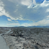
The Craters of the Moon VFE allows you to explore Craters of the Moon National Monument in Idaho. The area is a desolate landscape, shaped by volcanic activity in recent geologic time. The last eruption occurred about 2,000 years ago (and Earth is about 4,500,000,000 years old). The rock at the site is all volcanic in origin; primarily basalts of different forms.
This activity is an exploration of the Craters of the Moon and, it is suggested that the activity be done along with watching Making North America, Clip 1. The clip includes film from the Grand Canyon in Arizona and from the Hawaiian Islands. Craters of the Moon, like Hawaii, is a volcanic landscape made up primarily of different forms of basalt.
Analogies are important to geologists for understanding much - maybe all - of what we see and understand. If you don’t understand how something is like (or unlike) something else, you probably don’t really understand it. Of course, that’s not limited to geologists - explaining new ideas to people by referring to things they already know about is fundamental to all learning. It’s also at the core of scientific modeling. This can be straightforward. The rock pictured below is solidified from lava that is described as “ropey.”
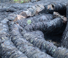
In many ways, the geology of Hawaii and the geology of Craters of the Moon National Monument are analogous. One shared characteristic is the presence of ropey rock. As you explore and compare the landscapes, consider the implications of the their similarities and differences, and consider how the similarities and differences to your own local landscape. If you can find rock forming in one place that produces rock that is like that from another place, it may well help you understand how that place came to be the way that it is. Of course, things can have a lot in common in their appearance or structure, but not actually come from the same process. It’s important to be cautious and ideally to have multiple forms of evidence.
Think about the climate and geology of where you live and what other places on Earth that might be analogous to home. And, very importantly, think about where the analogies have limits or work poorly of not at all.
Procedure
Exploration of Craters of the Moon National Monument in Google Earth and with the accompanying Prezi.
-
1.Download and open the Google Earth file of that includes “Craters of the Moon VFE.” The file is available here: http://virtualfieldwork.org/GEFiles/Craters-of-the-Moon-Idaho-VFE.kmz. It should take you directly to Craters of the Moon National Monument in Idaho. If not, double click on “Craters of the Moon VFE,” in the window on the left side of the screen. Craters of the Moon looks something like a giant spill of ink on the map.
-
2.If the folder “Craters of the Moon VFE” is not open, click the triangle in front of its name to show folder contents.
-
3.“Craters of the Moon - Granshaw” is another folder within the Google Earth file. Open this folder by clicking the triangle in front of the folder icon. Several folders showing different sites within the National Monument appear.
-
a.Check the check box in front of any of the folders to turn on its contents. Double-click the folder to zoom in on the site. A path will show the trail followed, with green dots to show the locations of interactive panoramas.
-
b.Click a green dot to view that location’s panorama. An image appears in the placemark’s balloon, with “Click here to move to ground view” beneath the image. Click that link. If an interactive panorama does not appear, click the button in the upper right corner of the screen to open the panorama in your browser. Note that when you return to Google Earth, you will need click the “Back to Google Earth” button in the upper left corner of the view window.
-
c.Explore a few panoramas. You can use the arrow keys on your keyboard, or the controls in the lower left of the screen to navigate.
-
d.Google Streetview is also available along park roads and in parking areas. Drag the Streetview icon (a.k.a., Pegman) from above the zoom control on the right side of the screen over the landscape. Roads with Streetview will highlight in blue. Drop Pegman anywhere on the blue highlighting to enter Streetview.
-
5.Explore Hawaii in Google Earth. Double click on the Hawaii folder to zoom to a view of Hawaii from above and check the box in front of the folder icon to view images and text for the folder before investigating its contents.
Connected Content
Use USGS’s State Geologic Map to identify rock ages and type local to your school. (Coming soon!)
Going Further
Craters of the Moon got its name, of course,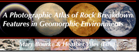 because in certain ways its landscape is analogous to the Moon’s. An especially important use of analogies in geology is for understanding the processes that made other planets look the way they do. Click on the image from A Photographic Atlas of Rock Breakdown Features in Geomorphic Environments (or the title) to access an 79 page booklet on the subject. The link is to a pdf.
Lesson Characteristics
Objectives
Use the VFE of Craters of the Moon National Monument in Prezi and Google Earth, and related content about Hawaii to:
-
•describe the features of volcanic landscapes that form above geologic hotspots
-
•compare and contrast landscapes in Hawaii and Idaho with attention to the value of analogous features for explaining landscape features.
Suggested prerequisites
-
•Familiarity with accessing the Internet
-
•Introduction to Google Earth
-
•Basic familiarity with maps
-
•Familiarity with rock types (sedimentary, metamorphic, and igneous)
Tools
-
•Computer with Internet access
-
•Google Earth software
Lesson Links
-
•The Prezi portion of this VFE is at the top of the page and also found here.
-
•The Google Earth file used in the activity is named Craters-of-the-Moon-Idaho-VFE.kmz. Click its name to download.
-
•Google Earth (free software; Google Earth Pro is now also available for free, though it is not required for this activity)
-
•Craters of the Moon National Monument website from the National Park Service.
-
•Teacher-Friendly Guides to the Earth Science of the United States, especially the chapter, Real and Virtual Fieldwork: "Why Does This Place Look the Way it Does?" and the appendix, The Teacher-Friendly Guides™, Virtual Fieldwork, and the NGSS’s Three-Dimensional Science
Selected images
GOING FURTHER
Why Does Craters of the Moon National Monument Look the Way it Does?Exploring Volcanic Landscapes
4,000 Years Ago