Adding Overlays in Google Earth

3.01 Taking an Excerpt of A Map, Article or Other File and Saving it to Picasa
Thursday, September 10, 2009
There are many ways to take an excerpt of a file and turn it into a picture that can be saved to Picasa or other photo sharing site. First, of course, you’ll need an image to work with. The US Geological Survey (USGS) has many high resolution, high quality maps available for free download. See more about that on virtualfieldwork.org’s Data and Map Sources page.
-
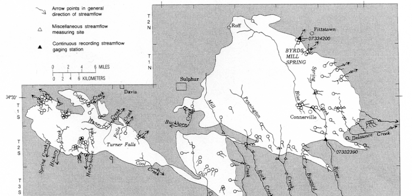
1.Download a map you’d like to use. This can be from one of the USGS sources or from an article or anywhere else you might find an electronic image of a map. For the tutorial, I’ll be using a map taken from a publication of the Oklahoma Geological Society, “Hydrology of the Arbuckle Mountains Area, South-Central Oklahoma” (Fairchild, Hanson & Davis, 1990).
-
•If you wish to do this the exact same way I do, download the article on the Arbuckles’ hydrology. If you wish to do something more directly useful for your own VFE or other Google Earth tour, choose an appropriate map from elsewhere.
-
-
2.After downloading the file, open the file.
-
-
3.The actual image capture, is a little different on a PC than it is on a Mac. Each platform has several different ways to save a screen or partial screen capture. If you already know how to do this, proceed with a method of your choice. We’ll show you one method that worked for us on each platform.
On a PC:
Instructions for how to capture what is on your screen and turn it into a jpeg:
PCScreenCapture.doc (MS Word)
PCScreenCapture.htm (webpage)
On a Mac:
1.Go to the Utilities folder within the applications folder and open ‘Grab.’ (If you are using Preview to look at a pdf file, you can also find Grab in the File menu).
2.From the ‘Capture’ menu within Preview, select ‘Selection.’
3.Drag over the portion of the screen you want to capture.
4.When you release the mouse, the new image opens.
5.Save it as either a jpg or tiff file with a descriptive name in a logical folder.
-
4.Upload to Picasa or other photo sharing site.
ADDING OVERLAYS IN GOOGLE EARTH
Google Earth Files Used in Tutorials:
TUTORIALS: