Dinosaur Ridge 1 Teacher Page

This is the introductory page for the teacher. See the student page here.
This lesson is one part of a large project designed to help educators teach about Regional and Local (ReaL) Earth system science in an inquiry-based way. This ReaL Earth Inquiry Project, and all of its related resources, support educators and students in the investigation of the project’s driving question: “Why does this place look the way it does?” The “place” of the question is anywhere you happen to be, but we hope and expect users of these materials will study areas outside their backdoor or their classroom door. The chapter, Real and Virtual Fieldwork: "Why Does This Place Look the Way it Does?" of our Teacher-Friendly Guides to the Earth Science of the United States addresses both actual and Virtual Fieldwork, and we believe the coupling of virtual and actual fieldwork is an excellent way to teach and learn, and it’s an approach that is fully three dimensional, in the The Next Generation Science Standards’ (NGSS’s) sense of that term. The Teacher-Friendly Guides™, Virtual Fieldwork, and the NGSS’s Three-Dimensional Science is the Appendix to the Guides and describes how the ReaL Earth Inquiry Project supports teaching that satisfies the NGSS. While reading more about the ReaL Earth Inquiry Project is a great thing to do, this lesson can stand alone.
We do ask that you apply the strategies and technologies employed in the lesson to the study of your local environment. Teachers and students can work together to create their own VFEs to both document their own fieldwork and to share what they learned with others. VFEs also allow continued investigation after leaving the field site.
NGSS Connections
This activity can be used to address the Performance Expectations listed below and more generally for addressing a range of Crosscutting Concepts and Science and Engineering Practices. No single lesson or small set of lessons, by itself, can be said to satisfy NGSS expectations. In order to satisfy those expectations, the activity must be part of a broader approach to the systems of understandings we are working to nurture in learners’ minds. Appendix K of NGSS notes, “The goal is not to teach the PEs, but rather to prepare students to be able to perform them by the end of the grade band course sequence.” It’s important to understand the basic three-dimensional structure of the NGSS before looking at the PEs or DCIs. For more on using Virtual Fieldwork to satisfy NGSS, see, The Teacher-Friendly Guides™, Virtual Fieldwork, and the NGSS’s Three-Dimensional Science. Fieldwork, whether real or virtual, is very well suited to engaging learners in three-dimensional science.
Most relevant middle school Performance Expectations:
-
•MS-ESS2-2. Construct an explanation based on evidence for how geoscience processes have changed Earth's surface at varying time and spatial scales.
-
•MS-ESS2-3. Analyze and interpret data on the distribution of fossils and rocks, continental shapes, and seafloor structures to provide evidence of the past plate motions.
Most relevant high school Performance Expectations:
-
•HS-ESS2-2. Analyze geoscience data to make the claim that one change to Earth's surface can create feedbacks that cause changes to other Earth systems.
-
•HS-ESS2-7. Construct an argument based on evidence about the simultaneous coevolution of Earth’s systems and life on Earth.
Some technical tips
You will want to have some familiarity with Google Earth yourself before having students use it in the classroom. You will also want to decide how preferences should be set. Do you want to use metric or imperial units? This can be set in the Google Earth menu under preferences, under the “3D View” tab. You’ll also want to set Elevation Exaggeration here. As this activity is set in the Rocky Mountains, the terrain is rugged and features will be easy to see without exaggeration. I recommend setting it, therefore, to 1.
This paragraph only applies if you choose to edit the content of the provided materials, or wish to create your own Google Earth files. Know too that Google Earth menus are not the same between Macs and PCs, but, as a general rule, right-clicking works the same on both platforms. The most important difference (in our opinion) is in how content within Google Earth is edited. On either the Mac or PC, you can edit the content of an element (like a placemark, path, or overlay) by right-clicking. On the Mac, choose “Get Info” from the menu that pops up. On the PC, choose “Properties.” Once you have entered edit mode, the behavior on Macs and PCs is largely the same. You should also regularly save content outside of Google Earth as unsaved changes may be lost in the event of a crash of the program. To do this, click to highlight the folder of material you wish to save and select “Save” from the “File” menu. Save it in a folder on your hard drive.
Lesson Characteristics
Lesson Title Linked to Student page
Grade Level
6-12
Subject
Earth Science/Geology
Objectives
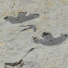
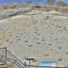
Use geologic maps in Google Earth to:
-
•determine rock ages and types for locations on a map, and,
-
•explain relationships amongst the arrangement, structures, and types of bedrock and the shape of the landscape.
Estimated Time for completing activity
90 minutes (two class periods)
Suggested prerequisites
-
•Familiarity with accessing the Internet
-
•Introduction to Google Earth
-
•Basic familiarity with maps
-
•Familiarity with rock types (sedimentary, metamorphic, and igneous)
Tools
-
•Computer with Internet access
-
•Google Earth software
Vocabulary
-
•ecosystem
-
•igneous rock
-
•lithify
-
•metamorphic rock
-
•plutonism
-
•sedimentary rock
-
•tectonic
-
•volcanism
To what unit does this lesson belong?
This unit could be included in either a mapping or geologic history unit, with connections to weathering, erosion and rock types. Connections could be used to either foreshadow coming units or review past units. Depending on how the lesson is approached, it can be used to either introduce or review geologic history and the geologic time scale.
Lesson Links
-
•Dinosaur Ridge Handout (the text on this page as a pdf or Word document)
-
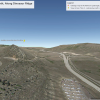
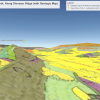
•The Google Earth file used in the activity is named MorrisonQuadrangle.kmz. Click its name to download.
-
•Google Earth (free software; Google Earth Pro is now also available for free, though it is not required for this activity)
-
•Teacher-Friendly Guides to the Earth Science of the United States, especially the chapter, Real and Virtual Fieldwork: "Why Does This Place Look the Way it Does?" and the appendix, The Teacher-Friendly Guides™, Virtual Fieldwork, and the NGSS’s Three-Dimensional Science
-
•Dinosaur Ridge Virtual Fieldwork Experience (Prezi) (Google Earth file)
Selected images
GOING FURTHER
About the roles of virtual and actual fieldwork in instruction