|
|
|
|


Virtual Fieldwork ExperiencesReaL Earth System Inquiry(ReaL stands for Regional and Local)The contents of this page are in the process of being transferred to new pages. We hope you find it useful. Some links may not work currently, but please check back.On this page... |
What is a Virtual Fieldwork Experience?What we strive for in developing VFEs A field scientist does not have a single possible way to operate in the field. Nor does she have a guide explaining what it is she's seeing at every turn. In the field, she might pick up a rock and take a closer look or pull out a magnifying glass and look at a cliff face. She probably would have access to references like maps and field guides (identication keys). Virtual fieldwork should offer some of the same opportunities for exploration as actually being in the field. We hope that there will be the occassional moment of discovery. These experiences are also intended to be an integral part of instruction, not a standalone activity. In some classrooms, they are being used to help prepare for actual fieldtrips and to process those excursions afterwards. It is perfectly reasonable to virtually visit a site several times for further data collection and to study different concepts at the same site. Scientists, of course, do this exactly. In considering virtual fieldwork as recurring practice, it makes sense that the initial experiences are more guided than the later experiences -- there is a gradual transfer of responsibility from teacher to student. What a VFE isn't Virtual Field Trips, or VFTs have become increasingly common at many levels of education. These experiences tend to be virtual tours rather than opportunities for inquiry. An Internet search will yield many examples of these tours as will a search of the Digital Library of Earth System Education (DLESE). Such resources clearly have value, but they can be seen as an opportunity for teachers to point things out. Learning for understanding involves students figuring things out. Two very different examples of what we strive for follow. Return to page content list. |
A VFE VignetteAs part of the project, we will be revising The Teacher Friendly Guide to Geology of the Northeastern United States (The TFG). This is a quality resource for understanding geology, but in its current form, does not provide guidance about how to help students learn about that geology through inquiry approaches. The TFG tells you (the teacher) much about why a place looks the way it does. In the revision, we are considering including vignettes (like this example) throughout the guide that illustrate how to or raise questions about teaching through inquiry. The vignette is modeled after those in The National Science Education Standards and describes how a VFE might look in a high school Earth science classrom. The story reflects a classroom familiar with fieldwork experiences. |
Virtual Fieldwork Experience Examples |
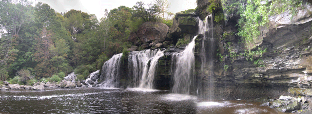
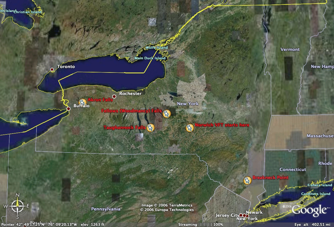
ReaL Pics Pages: Virtual Field Trips (VFTs) & VFT raw materialThese pages are unsorted collections of photographs taken by teacher participants in the National Science Foundation funded ReaL Earth System Inquiry . The program was hosted and coordinated by the Paleontological Research Institution and Colgate University. Below is a draft table of VFTs that will eventually take the form of a searchable database. Are the categories logical? Is anything missing? In viewing any of these photo sets, Sarah Miller's graphic organizer is a good place to start. That's also the lead into the most developed virtual field trip. ReaL Fieldtrips linked via Google Earth!!! Email me for this as an attachment. The server hosting this site does not currently serve kmz files. The problem is being addressed. The Google Earth file is primarily a way to connect the sites below. In the Google Earth (kmz) file, each location below is illustrated with a photograph and then links to the site for that location (that is, links to the site below). Nevele Falls (Still in draft form, but with lots to explore!) Look for a workshop on Virtual Fieldwork at the conference STANYS in November 2007! Jud & his New Hartford Colleague's Chapman Creek Tour Draft Large File! 14.3 MB! This VFT is the work of the Earth science teachers at Perry Junior High and it is a work in progress. It is a QuickTime Movie exported from Keynote. Keynote is Apple's presentation software, similar to PowerPoint in certain ways, some features of the interactive slide show export well to the interactive movie, but some features do not work quite as they do in Keynote. Accompanying worksheet (.doc) (.html) Joe's High Peaks (on Flickr.com) Kirk's Rocks -- Fellows (or Woodmancy) Fall Don's October 2006 Taughannock Pics Melisa's Akron Falls Pics on Flickr.com Don's Seneca & Fayette Quarries Melissa's ReaL Taughannock & Treman State Parks Pics In the Museum of the Earth Classroom New York Geologic Map (from University of Buffalo Libraries) (1.2 MB jpg) Key to NY Geologic Map From New York Geology Resource Forum Generalized Landscape Regions Map of New York State (from NYS Earth Science Reference Tables) The above resources and more will eventually be transferred to a searchable database. |
|
Essential & Unit Questions for Earth Science Two (Complementary & Research-Based) Views of Good Professional Development: (pdf) (html) |
| *This is a change of language. We initially spoke of virtual field trips (VFTs) rather than virtual fieldwork, but now recognize that the term has been in use for some time and many VFTs are more tours than inquiry experiences. Additionally, a field scientist is much more likely to refer to their research in the field as fieldwork than as a field trip. As the change is recent (January of 2007) we have not yet had time to update the language on this page. |
| This is an NSF funded Earth science teacher professional development program. The project is funded through NSF ESI-0455833. It is run cooperatively through The Paleontological Research Institution's Museum of the Earth and Colgate University. |
Possible Database Format for Virtual Fieldwork Experiences |
||||||
|
Author
|
Title with link
|
Location & Landscape Region
|
Abstract
|
Geologic Key Words
|
File Type/Description
|
Photo date(s)
|
|
Sarah Miller
|
Norwich, NY
Allegheny Plateau |
Use the graphic organizer to explore the geology of Norwich in this hike from Canaswacta Creek to the quarry a top West Hill. This VFT goes beyond a tour and uses embedded photos to allow students to explore. This VFT might be used multiple times in the course as increasing sophistication will allow students to gradually better answer the question "Why does this place look the way it does?"
|
Sedimentary rock, marine sedimentary rock, sandstone, glacial, valley, plateau, quarry, economic geology, stream
|
Interactive web site
Exploratory Field Trip |
Summer 2006
|
|
|
Don Duggan-Haas
|
Hamilton, NY
Allegheny Plateau |
The vignette takes the form of examples used in The National Science Education Standards (National Research Council, 1996). The vignette is a composite of experiences together with bits of fiction. All names are fictitious. The vignette is not intended to serve as a model of what to do but rather as food for thought.
|
Sedimentary rock, marine sedimentary rock, sandstone, limestone, plateau, quarry, economic geology
|
Web site with vignette and unstructured photo set
|
Spring & Summer 2005
|
|
|
Allers, Cleveland & Spanneut
|
New Hartford, NY
Line between Tug Hill Plateau and Hudson-Mohawk Lowlands |
The VFT guides you along Chapman Creek on Parry Middle School's property. The creek crosses the line between two landscape regions -- the Tug Hill Plateau and the Hudson-Mohawk Lowlands. The technological design is highlighted by clickable questions. For example, to evaluate topographic map reading skills, students can click on arrows to indicate direction of stream flow. |
Uncomformity, conglomerate, landscape regions, plateau, lowlands, waterfalls
|
Quicktime Interactive Movie originally created using Apple's Keynote software; accompanying worksheet
Guided Tour |
November 2006
|
|
| Return to page content list. | ||||||
Clickable Map |
|
Coming soon! Google Earth file linking the above locations. A file does exist, but the server is not currently configured for kmz and kml files. Contact Don for the file. |
|
Below offers a hint of what the above file does in Google Earth.
|
More ReaL Information: |
|
Geological Society of America, October 2006: Ross, Robert M., Paleontological Research Institution, Duggan-Haas, Don, Department of Educational Studies, Colgate University, Miller, Sarah R., Norwich High School, and, Humbert, S. Elizabeth, Paleontological Research Institution Facilitating Acquisition Of Pedagogical Content Knowledge In Early Career Earth Science Teachers: The ReaL Earth System Inquiry Project GSA 2006 ReaL Conference PowerPoint (ppt (a very large file)) (html) |
| Institute Agenda. The program officially began with an institute at The Museum of the Earth from August 14 through August 19, 2005. |
| Lab plot. This simple grid is intended to provide fodder for discussion on the nature of school laboratory work. For more fodder, see America's Lab Report, a report on the state of school laboratories from National Academy Press. |
| Specimen Labels. Useful for your field trips. |